SAR Hawker V2
m |
m |
||
| Line 97: | Line 97: | ||
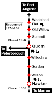
<span style="font-weight: 700;"><span style="color: white; background-color: black;"> Distance from Quorn: </span> 66 kms, 41 miles</span><br> | <span style="font-weight: 700;"><span style="color: white; background-color: black;"> Distance from Quorn: </span> 66 kms, 41 miles</span><br> | ||
| − | Unmanned location on the <span style="font-weight: 700; color: white; background-color: black;"> Port Augusta-Hawker Line </span>. | + | Unmanned location on the <span style="font-weight: 700; color: white; background-color: black;"> Port Augusta-Hawker Line </span> which was originally part of the <span style="font-weight: 700; color: white; background-color: black;"> Commonwealth Railways </span> <span style="font-weight: 700; color: white; background-color: black;"> Port Augusta-Alice Springs Line </span>. |
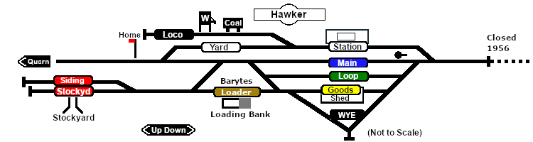
Station, goods, mineral loading bank and shunting loops, stockyard siding, loco servicing facilities and a turning WYE.<br> | Station, goods, mineral loading bank and shunting loops, stockyard siding, loco servicing facilities and a turning WYE.<br> | ||
| − | '''Hawker''' became the terminus when the line to '''Marree''' was closed in 1956.<br> | + | '''Hawker''' became the terminus when the line to '''Marree''' was bypassed and closed in 1956.<br> |
Mineral traffic (barytes, a form of barium sulfate) from a mine 70km north of '''Hawker''' was the main reason the line remained open after 1956. The mineral was trucked to '''Hawker''' and then railed to a crushing and bagging mill at '''Quorn''' for shipment by rail throughout the country. Rail was used between '''Hawker''' and '''Quorn''' because of the poor condition of the roads.<br> | Mineral traffic (barytes, a form of barium sulfate) from a mine 70km north of '''Hawker''' was the main reason the line remained open after 1956. The mineral was trucked to '''Hawker''' and then railed to a crushing and bagging mill at '''Quorn''' for shipment by rail throughout the country. Rail was used between '''Hawker''' and '''Quorn''' because of the poor condition of the roads.<br> | ||
From the 1960s there was only a single scheduled freight service each week. There were no passenger services. The line was closed in 1972.<br> | From the 1960s there was only a single scheduled freight service each week. There were no passenger services. The line was closed in 1972.<br> | ||
| − | |||
</td> | </td> | ||
</tr> | </tr> | ||
Latest revision as of 11:33, 22 January 2026
|
|