File:SAR Quorn-Woolshed Flat Strip Map V2.png
From TrainzOnline
(Difference between revisions)
(Strip map for Quorn to Woolshed Flat V2) |
(Pware uploaded a new version of "File:SAR Quorn-Woolshed Flat Strip Map V2.png": Update) |
Latest revision as of 09:41, 12 June 2024
Strip map for Quorn to Woolshed Flat V2
File history
Click on a date/time to view the file as it appeared at that time.
| Date/Time | Thumbnail | Dimensions | User | Comment | |
|---|---|---|---|---|---|
| current | 09:41, 12 June 2024 | 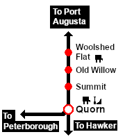 | 180 × 200 (11 KB) | Pware (Talk | contribs) | Update |
| 09:33, 12 June 2024 | 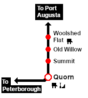 | 180 × 200 (7 KB) | Pware (Talk | contribs) | Strip map for Quorn to Woolshed Flat V2 |
- Edit this file using an external application (See the [//www.mediawiki.org/wiki/Manual:External_editors setup instructions] for more information)
File usage
The following 2 pages link to this file: