SAR Paratoo

From TrainzOnline
(Difference between revisions)
Jump to: navigation, search
m
m
Line 8: Line 8:
 
</tr>
 
</tr>
 
<tr valign="top">
 
<tr valign="top">
<td align="center">[[image:Tab_HM_White.png|link=]]&nbsp;[[image:Tab_IN_Grey.png|link=SAR_Paratoo_Industry]]&nbsp;[[image:Tab_TM_Grey.png|link=SAR_Paratoo_TrackMarks]]&nbsp;[[image:Tab_Blank_Grey.png|link=]]&nbsp;[[image:Tab_SW_Grey.png|link=SAR_Paratoo_Switches]]</td>
+
<td align="center">[[image:Tab_HM_White.png|link=]]&nbsp;[[image:Tab_IN_Grey.png|link=SAR_Paratoo_Industry]]&nbsp;[[image:Tab_TM_Grey.png|link=SAR_Paratoo_TrackMarks]]&nbsp;[[image:Tab_PH_Grey.png|link=SAR Paratoo Paths]]&nbsp;[[image:Tab_SW_Grey.png|link=SAR_Paratoo_Switches]]</td>
 
</tr>
 
</tr>
 
<tr valign="top">
 
<tr valign="top">

Revision as of 19:59, 31 January 2021

Line740.png
Tab HM White.png Tab IN Grey.png Tab TM Grey.png Tab PH Grey.png Tab SW Grey.png
Line740.png
PortPirie-BrokenHill
Methuen
Location Index   PortPirie-BrokenHill

Paratoo map

 Commodities: 
Passengers
Passengers
Station Label.png
Goods
Goods
Goods Label.png
Livestock
Livestock
Stockyard Label.png
   
 Loco Services: 
Coal
Coal
Loco Label.png
Water
Water
Main Label.png
Loop Label.png
 
 Facilities: 
Loop
Loop
Loop Label.png
WYE
Turning
WYE Label.png
   

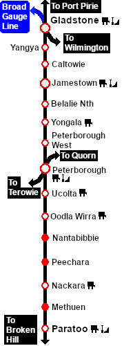
Manned station on the  Port Pirie-Broken Hill Line .

Station, passing and goods loops with a stockyard siding, a Loco water/coaling facility and a turning WYE.

Paratoo was the only location on the line with a dedicated signal box.

After the conversion of the line to standard gauge (1969-70) all loops, sidings and facilities were removed from Paratoo. There is now little evidence of its original role or importance.

Line740.png

PortPirie-BrokenHill

Gladstone-Paratoo Strip Map
Personal tools