User:Darkrose289
Darkrose289 (Talk | contribs) (→Yard descriptions) |
Darkrose289 (Talk | contribs) (→DarkRose Logistics) |
||
| (5 intermediate revisions by one user not shown) | |||
| Line 55: | Line 55: | ||
|- | |- | ||
| Last Updated: | | Last Updated: | ||
| − | | | + | | 19 January 2026 as 'DarkRose_012-013-19-61BB' |
|- | |- | ||
| Current KUID: | | Current KUID: | ||
| − | | Route: kuid:806504: | + | | Route: kuid:806504:101005<br /> Session: kuid:806504:101007 |
|- | |- | ||
| Asset Version: | | Asset Version: | ||
| Line 69: | Line 69: | ||
<div style="column-count:2"> | <div style="column-count:2"> | ||
Y1 - Steel City<br /> | Y1 - Steel City<br /> | ||
| − | Y2 - Black Mountains Oil Refinery | + | Y2 - Black Mountains Oil Refinery<br /> |
Y3 - Crystal Chemicals & Plastics<br /> | Y3 - Crystal Chemicals & Plastics<br /> | ||
Y4 - Dark Rose Logistics and Maintenance<br /> | Y4 - Dark Rose Logistics and Maintenance<br /> | ||
| Line 196: | Line 196: | ||
::* Reconfigured the double crossover next to the fuel depot into two single crossovers | ::* Reconfigured the double crossover next to the fuel depot into two single crossovers | ||
::* Changed track assets from wood sleepers and ballast to concrete sleepers and no ballast | ::* Changed track assets from wood sleepers and ballast to concrete sleepers and no ballast | ||
| + | : Y2 Screenshot(s): [[File:Y2_2026-01-01_173402.jpg|frameless|180px]] | ||
: Yard 3 | : Yard 3 | ||
| Line 286: | Line 287: | ||
: March | : March | ||
::* As of 01MAR20 there is almost 125,000,000 square meters (48.25 sq miles) of usable space. I haven't calculated how much track length is running around this route...yet. | ::* As of 01MAR20 there is almost 125,000,000 square meters (48.25 sq miles) of usable space. I haven't calculated how much track length is running around this route...yet. | ||
| + | |||
| + | : Yard 2 | ||
| + | : Y2 Screenshot(s): [[File:Y2_2020-04-27_111828.jpg|frameless|180px]] | ||
===== 2017 (T:ANE/SP1/SP2) ===== | ===== 2017 (T:ANE/SP1/SP2) ===== | ||
Latest revision as of 09:53, 20 January 2026
Contents |
[edit] Dark Rose Routes
Welcome to my Trainz page, the inner workings of my Trainz brainz, and my latest updates on my route projects.
[edit] Acknowledgements/Credits
All assets in my routes were downloaded from the DLS or built-in with the Trainz software. Credit and much thanks to all the original and editing authors of the assets in the routes and on the DLS. Your hard work and dedication is greatly appreciated and has made my route building projects fun! Thank you also to Auran and N3V for keeping Trainz on track!
All Trainz assets used in my routes retain original authors' and editing authors' copyright protections in accordance with N3V Games Pty Ltd MyTrainz Agreement and applicable copyright laws.
Deadwood Creek route:
- Westcott, L. H. (1956). 101 Track Plans for Model Railroaders (11th ed.). Kalmbach Publishing Company. Eleventh printing 1976.
- The original layout cannot be used for payware or uploaded to the DLS without written permission from Kalmbach Media (https://www.kalmbach.com/contact-us/). Please also refer to N3V Games DLS upload policy pertaining to copyrighted material.
[edit] Experience/Skills
[edit] Life
Newspaper delivery
Grocery Store
- cashier
- product replenishment
- bakery
- florist
- produce
Security guard (on-call officer)
U.S. Army (retired)
Electronics repair/maintenance
Degrees
- Bach. Sci. Info Tech
- Masters Info Systems w/ cert IS audit
Knowledge Management
Training Manager
Hobbies
[edit] Trainz
[edit] Projects
Current:
- DarkRose Logistics
- Personal Trainz Wiki page - will be adding screenshots in the near future
Others:
- Beginners Route from scratch
- Deadwood Creek layout
[edit] Routes
[edit] DarkRose Logistics
| Created: | 02 March 2017 as 'trnz_layout_016' kuid 806504 100001 |
| Last Updated: | 19 January 2026 as 'DarkRose_012-013-19-61BB' |
| Current KUID: | Route: kuid:806504:101005 Session: kuid:806504:101007 |
| Asset Version: | 12.12.30.08 (map_number.map_version.major_edit_version.minor_edit_version) |
This Trainz route was inspired by an HO scale route I created using AnyRail Model Railroad Builder which the last route version update (around 2015) is layout_11_13. This route was named Route_11_13 and was designed with significantly more distance between industries. Part of this route is inspired from a couple of railroad routes in Manchester, CT (using a 1952 topographical map & present-day Google maps) when the rails to the Cheney Mills still existed.
[edit] Yard descriptions
Y1 - Steel City
Y2 - Black Mountains Oil Refinery
Y3 - Crystal Chemicals & Plastics
Y4 - Dark Rose Logistics and Maintenance
- Y4N - Consist Staging, Freight rail maintenance, and MOW
- Y4S - CONEX Sorting Operations
Y5 - (Forestry, Lumber, and Paper Industry)
- Y5A - (Forestry/Logging)
- Y5B - (Lumber Mill)
- Y5C - (Paper Mill Industry)
Y6 - (Passenger Train Service)
Y7 - Westover Power Plant
Y8 - Waynesburg Coal Mine
- Y8N - Barnickle Quarry Company
Y9 - Northern Electric Company (NEC) Power Plant
Y10 - Maritime Port and Trade Services Yards
- Y10A - Skagway Oil Company
- Y10B - SeaStar Port Storage and Distribution, LLC
- Y10C - Polar Ice Co.
- Y10D - Rod & Fish, LLC
- Y10E - (Intermodal CONEX yard - under construction)
[edit] Naming/Labeling standard
This section is primarily used for track objects but similar labeling methods can be adapted for other assets as desired. Letter indicates asset type, followed by first 1 or 2 digit(s) for the yard #, two or more digits for serial number. The "standard" only applies to routes I create.
Yards
- Y# - Yard #
- 10 and higher will use the colon to separate the yard number from the asset serial number.
- Example: Yard 1, 89th signal in the yard, gantry mounted = G189
- Example: Yard 3, 16th junction in the yard = J316
- Example: Yard 10, 96th signal in the yard, dwarf mounted = D10:96
- 10 and higher will use the colon to separate the yard number from the asset serial number.
- B - Bumper/Buffer [a]
- D - Dwarf Signal
- DL - Dwarf Diverge Left
- DR - Dwarf Diverge Right
- G - Gantry Signal
- GL - Gantry Diverge Left
- GR - Gantry Diverge Right
- IS - Invisible signals [b]
- S - Searchlight signal
- SL - Searchlight Diverge Left
- SR - Searchlight Diverge Right
- SC - Signal Controller
Junctions
- J - yard# seq.# ex., J161 means 61st junction in Yard 1
- JC - Junction Controller v4 <kuid2:439337:100957:1> MSGSapper
- JS - Junction Speed controller <kuid2:137715:23001:5> BPanther
- GC or GCM - Grid Coordinate marker [c]
- LM - Layout Marker [c]
- P - Priority marker: Priority Level:Priority S/N (yard # sequence #) Pn:y#s##:: P1:600; P2:302; P3:406
- TD - Track Direction Marker
- TM - Track Marker [d]
- TR - Trigger (built-in)
-
TC - Trigger Clickety Clack (only used where two or more tracks intersect, very rare so far.)marked for deletion - TI - Schedule Station Info Trigger
- TX- Trigger (ASB Crossover Trigger TRS19)
- TXC - ASB Crossover Corrector (planned for deletion from route)
Track Circuit
- Y#:0 - Track Circuit Detector
- Y#:# - Track Circuit Insulator
- Mile Markers (KUID:39134:100325 by bnsf50) [e]
- Main Route:
- Obverse: [Named Area],[Region],[Distance]
- Ex: MR,CT,0.0 is Manchester, Connecticut (CT), 0.0 miles heading towards MR,CT,0.5
- Reverse: [Distance],[Region],[Named Area]
- Ex 1: 1.0,CT,MR is Manchester, CT, 1.0 mile heading towards 0.5,CT,MR
- Ex 2: 5B,SF,0.0 is 5 Bridges State Forest
- Obverse: [Named Area],[Region],[Distance]
- Mile Marker Short Titles and Descriptions:
- 5B SF - 5 Bridges State Forest
- BM OR - Black Mountains Oil Refinery
- BQ PA - Barnickle Quarry, Pennsylvania (PA)
- CV BC - Cowichan Valley, British Columbia
- DW No - Desert Wye, North
- DW So - Desert Wye, South
- EH CT - East Hartford, Connecticut (CT)
- GE NE - Greenhills Express, North East
- GE SE - Greenhills Express, South East
- KB CV - Kinsol Bridge, Cowichan Valley
- KF LC - Kestrel Forest Lumber Company
- MR CT - Manchester, CT
- RL Y4 - Rose Logistics, Yard 4
- SC PA - Steel City, PA
- SY Y10 - Skagway Oil Co., Yard 10
- WG PA - Waynesburg, PA
- WN NY - Watertown, New York (NY)
Label Notes
- a.↑ Technically not a signal in the real world, but in Trainz it does act like a permanent red signal at the end of a track. Putting a regular signal before the bumper/buffer will cause the signal to display a yellow/amber aspect.
- b.↑ Rarely used anymore. Mostly found in the earlier versions of the route (primarily in T:ANE). They were useful in crossovers to help the signals display correctly but as Trainz evolved and I gained more experience, invisible signals have been mostly deleted from the route...when I find them.
- c.↑ Using <kuid2:413547:100191:1> 'AC KS marker1' by Wedge_Antillies. These are placed in the Coord and Layout Marker layers respectively. Both layers are normally locked but the Coord layer is always visible while the Layout Marker is normally hidden. The layout markers help to "preserve" the original vertices of tracks usually at bridge or tunnel endpoints, tunnel mid points, and for track guide assets.
- d.↑ Most frequently named with yard number and track number; i.e. Y4 T1 E = Yard 4 Track 1 East); Otherwise the TM number is semi-arbitrary and used to test or time train movements to determine the best possible distance for junction triggers and controllers.
- e.↑ Since the main route encircles almost the entire map, the mile markers do not indicate compass point headings but they do indicate whether the train is traveling towards an area's limits or away from it (like the autobahn signs in Germany and other parts of Europe). Of course every time I tweak any tracks with mile markers the measurements need to be redone (rolling my eyes so hard I can see my brain).
[edit] Major updates
[edit] 2026
- General
- Crossover at TM1514 removed two invisible signals - no longer needed
- Bulk replaced Junction Controller v3 with v4
- Since the red and green arrows have disappeared from all of the junctions, I started replacing US&S unlighted switches with the version with lights. I have checked every setting possible in driver and surveyor modes (i.e., Junction Overlay: ON) and the only time I see the arrows is in Map view. There are no session rules or scripts in the 'Edit Session...' except for the default rules/scripts and none of those are reporting any errors.
- Repaired unintentional Smooth Ground Under Selected (SGUS) on two tunnels just outside the Y1 North area
- added Track Yellow Invisible Driver in the contour-lines layer at vertices of tunnel and bridge end points to prevent their selection when double clicking on regular track splines for SGUS application
- Yard 1
- added two warehouses and adjusted existing ones
- Yard 2
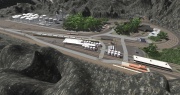
- Reconfigured the double crossover next to the fuel depot into two single crossovers
- Changed track assets from wood sleepers and ballast to concrete sleepers and no ballast
- Y2 Screenshot(s):

- Yard 3
- Changed track assets from wood sleepers and ballast to concrete sleepers and no ballast
- Added two warehouses and about a dozen and a half of truck trailers. Warehouse 1 is designated for dry or solid chemical products, Warehouse 2 is designated for liquid and gas products storage, and the third warehouse asset Is the product distribution center
- added two more warehouses and several 53' tanker trailers
- fixed track alignment for the west side warehouse bypass.
[edit] 2025
- General
- 10 years of building and editing this route!! (counting non-Trainz-layout-editor time)
- Updated plants and assigned layers for deciduous, conifer, and bushes/flowers
- Move the Engines & Rolling Stock layer to the Session layers
- TM1514: replaced tunnel with bridge and leveled terrain
- Baseboard count
- 1,024 (32 x 32)
- 23.04 km x 23.04 km (530.8416 sq km or 530,841,600 sq m)
- ~ 14.32 miles x 14.32 miles (204.96 sq miles or about 7½ times smaller than the state of Rhode Island)
- Yard 1
- Updated steel industry track layout and alignments; new signal bridges added
- Steel City Amtrak™ overpass: Replaced steel through-truss bridges with simpler 2-track plate-girder bridge.
- Added container yard (plans to add container yards in Y10 and Y4)
- Yard 3
- added a bypass route to the West of Yard 3, starts at the east end of Y4 South and ends roughly 1.5 miles (~2.41km) SW of southern end of Y3
- 'modernized' the layout of track to be more realistic and improve yard navigation
- Corrected the curved portion of the 7 tracked West-side yard to make the 22.5° arcs conform to 'Guide Curve 225 Meter CG' and 'Guide Curve 200 Meter CG'
- Updated ballast to 'TS09 Ballast' to match the ballast in 'TRS19 Track 1 Procedural - Seasonal'
- Added an asset: SAP_Chemical_Plant_1_PBR to have more chemical plant scenery; made minor adjustments to the existing tracks to accommodate the Chemical Plant.
- Added two bridges and extended the roads on the west side of the ridge next to the Chemical production facilities; cleared trees and grass from the roads; performed "lawn mowing" along the Y4-to-Y7 bypass route to reduce some of the grass and clutter
- "declared" the small lake a hazardous waste area; added warning signs, and orange plastic construction fence around a derelict building foundation, and rusty corrugated pipes
- added some trucks to haul tanktainers that were already in the yard; added a RHTC to move tanktainers
- Yard 4
- Major overhaul of Yard 4
- Yard 4 South (Y4S): added a 2-mile long 31-track wide sorting/staging yard (inspired by CSX mega railyard seen in Modern Marvels)
- Yard 4 North (Y4N): kept the original yard as a secondary CONEX yard, Locomotive Maintenance Facility (LMF), and MOW base of operations; added 12 engine sheds between the CONEX yard and LMF as a holding area for engines ready to return to service
[edit] 2024
- January
- reconfigured track layout for the eastern portion of Yard 10
- created natural blast barriers around POL storage tanks;
- added retaining walls around the main yard (SW potion of Yard 10)
- converted all baseboards from 5m grid to HD grid
- started experimenting with the 'Smooth under asset' with 0.75m radius in some of the areas where two different height tracks are in close proximity to each other
- April-May
- 3 Bridges State Forest is now 5 Bridges State Forest
- Improved track alignments, replaced bridges, added two bridges;
- freight lines moved to 15m elevation, passenger line moved to 0m elevation
- June-July
- Yard 7
- Added 3 new buildings to the Westover Power Plant;
- replaced and realigned the parking lots;
- added a helicopter pad with stairs to an external upper level door;
- added red warning beacons to the power plant and helipad, added color lights to the helipad for night operations;
- added a white strobe light to the two hi-rise buildings;
- rebuilt the entire track layout in the yard to fix alignment issues and 'doubled sleepers' on several of the lanes.
- Yard 7
- Yard 1
- moved the 'Steel Industry - Continuous-Process Strip Mill'(CPSM) to the western end of the yard
- added 3 blast furnaces between the CPSM and the passenger train bridge. Each blast furnace has a industry track added to allow drop-off of coal, iron ore, etc. and pick up steel coils, beams, etc.
- Yard 1
[edit] 2023
- November
- Added Iron Ore Mine/Tipple near the quarry
- Started using Measuring Wagon Consist (Author: Willem2) to post mile markers along the main route starting at xyz: -9128.13m, -337.79m, 61m. mile marker naming conventions listed below.
- December
- plotted 73.68 miles (~ 118.58 km) of main line track
[edit] 2022 (TRS22)
- July
- First time using TRS22
- Base Route Created: 02JUL22 15:02:28
- Last modified: 02JUL22 17:24:58
- Mod. Route Version: 12.00.00.01
- Mod. Route Build: 1
- KUID:806504:100099
- Increased total baseboards to 1,024 baseboards arranged 32 x 32; the base has 530,841,600 square meters (204.96 sq miles) of usable space.
- Added markers to indicate baseboard zones and map coordinates.
- The 32 x 32 baseboard is divided into 16 equal zones of 8 x 8 and number using hexadecimal values 0 - F. Numbered assets not associated with a yard are assigned a number where the 1st two characters after the asset type designator is the zone number and then followed by a 3-digit serial number.
[edit] 2020 (TRS19)
- March
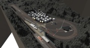
- As of 01MAR20 there is almost 125,000,000 square meters (48.25 sq miles) of usable space. I haven't calculated how much track length is running around this route...yet.
- Yard 2
- Y2 Screenshot(s):

[edit] 2017 (T:ANE/SP1/SP2)
(gathering data)
[edit] Deadwood Creek
[edit] Achievements and Metrics
[edit] Other pages
HowTo/Fix Errors and Warnings (contributor)