From TrainzOnline
(Difference between revisions)
|
|
| Line 1: |
Line 1: |
| | <!-- V1.0 --> | | <!-- V1.0 --> |
| − | <table> <!-- BEGIN TOP TABLE --> | + | <table width=1000> <!-- BEGIN TOP TABLE --> |
| | <tr valign="top"> | | <tr valign="top"> |
| | <td width=750> | | <td width=750> |
| Line 33: |
Line 33: |
| | </tr> | | </tr> |
| | <tr valign="top"> | | <tr valign="top"> |
| − | <td align="center"><span style="font-weight: 700;">This is the original <span style="color: blue;">v1.0 Halls Well Map and description</span>. For the latest <span style="color: blue;">SAR Peterborough Narrow Gauge Division v2.0</span> version click <span style="background-color: yellow;">[[SAR_Halls_Well_V2|here]]</span>. The V2.0 version of the route and sessions requires Trainz Plus or TRS22</span><br> | + | <td align="center"><span style="font-weight: 700;">For <span style="color: blue;">SAR Peterborough Narrow Gauge Division v1.0</span>. For the latest <span style="color: blue;">V2.0</span> click <span style="background-color: yellow;">[[SAR_Halls_Well_V2|here]]</span></span></tr> |
| − | [[Image:line740.png|link=]]</td> | + | </table> |
| | + | |
| | + | <table width=750> |
| | + | <tr valign="top"> |
| | + | <td align="center">[[Image:line740.png|link=]]</td> |
| | </tr> | | </tr> |
| | </table> | | </table> |
Latest revision as of 10:10, 2 May 2024
 |
| For SAR Peterborough Narrow Gauge Division v1.0. For the latest V2.0 click here |
|
|
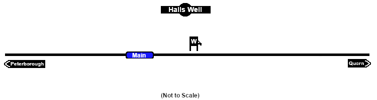
Loco Services:

Water
 |
|
|
|
|
|
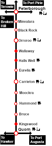
Distance from Peterborough: 51½ kms, 32 miles
Unmanned location on the Peterborough-Quorn Line .
A water tower on the main line. No sidings or loops.
The tank was filled with water from a well which was purchased from a Mr Hall in 1897 (hence the name Halls Well) and was notable as being the only source of underground water used by the SAR. It was mostly used as a "top-up" for freight trains making the long climb from Orroroo to Eurelia which has some of the steepest grades on the line.
|
 |
|

 |
