SAR Gumbowie V2
(Created page with "<!-- V2.0 --> <table width=1000> <!-- BEGIN TOP TABLE --> <tr valign="top"> <td width=750> <table width=750> <!-- BEGIN TABBED link list with Home page active--> <tr valign...") |
m |
||
| (One intermediate revision by one user not shown) | |||
| Line 16: | Line 16: | ||
</table> <!-- END TABBED link list --> | </table> <!-- END TABBED link list --> | ||
| − | <table bgcolor="lightgrey" bordercolor="lightgrey" width=750> <!-- BEGIN | + | <table bgcolor="lightgrey" bordercolor="lightgrey" width=750> <!-- BEGIN location link table with LINE and STATION NAMES --> |
<tr valign="middle"> | <tr valign="middle"> | ||
| Line 26: | Line 26: | ||
</tr> | </tr> | ||
| − | </table> <!-- END | + | </table> <!-- END location link table with LINE and STATION NAMES --> |
<table width=750> | <table width=750> | ||
| Line 33: | Line 33: | ||
</tr> | </tr> | ||
<tr valign="top"> | <tr valign="top"> | ||
| − | <td align="center"><span style="font-weight: 700;"> | + | <td align="center"><span style="font-weight: 700;">For <span style="color: blue;">SAR Peterborough Narrow Gauge Division v2.0</span>. For the original <span style="color: blue;">V1.0</span> click <span style="background-color: yellow;">[[SAR_Gumbowie_V1|here]]</span></span></td> |
| − | < | + | </tr> |
| − | [[Image:line740.png|link=]]</td> | + | </table> |
| + | |||
| + | <table width=750> | ||
| + | <tr valign="top"> | ||
| + | <td align="center">[[Image:line740.png|link=]]</td> | ||
</tr> | </tr> | ||
</table> | </table> | ||
| Line 93: | Line 97: | ||
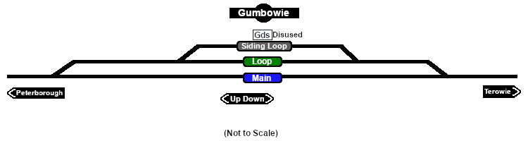
A signal box and a small station building that were originally present on the main line had been removed by the start of the 1960s. After '''Belalie North''' was bypassed by the gauge conversion (1969-70) '''Gumbowie''' at 610m (2001ft) became the highest point in the '''SAR''' system.<br> | A signal box and a small station building that were originally present on the main line had been removed by the start of the 1960s. After '''Belalie North''' was bypassed by the gauge conversion (1969-70) '''Gumbowie''' at 610m (2001ft) became the highest point in the '''SAR''' system.<br> | ||
| − | The main line and crossing loop were converted to dual gauge with the addition of a | + | The main line and crossing loop were converted to dual gauge with the addition of a standard gauge (4ft8½in - 1435mm) track to the existing narrow gauge (3ft6in - 1067mm) main line and loop in 1970 but the siding remained narrow gauge only. The '''Peterborough-Terowie Line''' was closed in 1988.<br> |
Today nothing remains at '''Gumbowie''' to indicate that it was once a railway location. | Today nothing remains at '''Gumbowie''' to indicate that it was once a railway location. | ||
Latest revision as of 15:09, 11 November 2025
|
 |