SAR Index V2
From TrainzOnline
(Difference between revisions)
m |
m |
||
| (4 intermediate revisions by one user not shown) | |||
| Line 1: | Line 1: | ||
<!-- V2.0 (seperate V1.0 file) --> | <!-- V2.0 (seperate V1.0 file) --> | ||
| − | <table width= | + | <table width=1000> |
<tr valign="top"> | <tr valign="top"> | ||
<td align="center" width=800><span style="background-color: blue; color: white; font-weight: 700; font-size: 21px"> SAR Peterborough Narrow Gauge Division v2.0 </span></td> | <td align="center" width=800><span style="background-color: blue; color: white; font-weight: 700; font-size: 21px"> SAR Peterborough Narrow Gauge Division v2.0 </span></td> | ||
| Line 10: | Line 10: | ||
</tr> | </tr> | ||
<tr valign="top"> | <tr valign="top"> | ||
| − | <td align="center">[[Image:Location Index.png|link=|alt=Location Index]]<br>'''All links will open in this window'''</td> | + | <td align="center">[[Image:Location Index.png|link=|alt=Location Index]]<br> |
| + | '''All links will open in this window'''</td> | ||
<td align="center">[[image:Session Scenario Index.png|link=SAR Peterborough Base Session V2|alt=Scenarios|Scenarios Index]] [[image:SAR Tutorial.png|link=SAR Scenarios Tutorial V2|alt=Tutorial|Drive Tutorial]]</td> | <td align="center">[[image:Session Scenario Index.png|link=SAR Peterborough Base Session V2|alt=Scenarios|Scenarios Index]] [[image:SAR Tutorial.png|link=SAR Scenarios Tutorial V2|alt=Tutorial|Drive Tutorial]]</td> | ||
</tr> | </tr> | ||
| Line 17: | Line 18: | ||
<table width=800> | <table width=800> | ||
<tr valign="top"> | <tr valign="top"> | ||
| − | <td align="center"><span style="font-weight: 700;"> | + | <td align="center"><span style="font-weight: 700;">This is the updated <span style="color: blue;">SAR Peterborough Narrow Gauge Division V2.0</span> index. For the original <span style="color: blue;">V1.0</span> index click <span style="background-color: yellow;">[[SAR_Index_V1|here]]</span></span></td> |
</tr> | </tr> | ||
</table> | </table> | ||
| Line 68: | Line 69: | ||
<table> | <table> | ||
<tr valign="middle"> | <tr valign="middle"> | ||
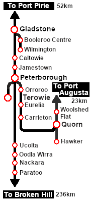
| − | <td>[[Image:SAR_Peterborough-Terowie_Line.png|link=SAR Peterborough- | + | <td>[[Image:SAR_Peterborough-Terowie_Line.png|link=SAR Peterborough-Terowie_V2|alt=Peterborough-Terowie Line|Show Peterborough-Terowie Line]] </td> |
<td><span style="font-weight: 700; background-color: black; color: white;"> 23km - 14mi </span></td> | <td><span style="font-weight: 700; background-color: black; color: white;"> 23km - 14mi </span></td> | ||
</tr> | </tr> | ||
| Line 83: | Line 84: | ||
<table> | <table> | ||
<tr valign="middle"> | <tr valign="middle"> | ||
| − | <td>[[Image:SAR_Peterborough-Quorn_Line.png|link=SAR Peterborough- | + | <td>[[Image:SAR_Peterborough-Quorn_Line.png|link=SAR Peterborough-Quorn_V2|alt=Port Peterborough-Quorn Line|Show Peterborough-Quorn Line]] </td> |
<td><span style="font-weight: 700; background-color: black; color: white;"> 137km - 85mi </span></td> | <td><span style="font-weight: 700; background-color: black; color: white;"> 137km - 85mi </span></td> | ||
<td><span style="font-weight: 700;"><span style="background-color: blue; color: white;"> Updated </span> terrain in <span style="color: blue;">v2.0</span></span></td> | <td><span style="font-weight: 700;"><span style="background-color: blue; color: white;"> Updated </span> terrain in <span style="color: blue;">v2.0</span></span></td> | ||
| Line 122: | Line 123: | ||
<table> | <table> | ||
<tr valign="middle"> | <tr valign="middle"> | ||
| − | <td>[[Image:SAR_Gladstone-Wilmington_Line.png|link=SAR Gladstone- | + | <td>[[Image:SAR_Gladstone-Wilmington_Line.png|link=SAR Gladstone-Wilmington_V2|alt=SAR Gladstone-Wilmington Line|Show Gladstone-Wilmington Line]] </td> |
<td><span style="font-weight: 700; background-color: black; color: white;"> 88km - 54mi </span></td> | <td><span style="font-weight: 700; background-color: black; color: white;"> 88km - 54mi </span></td> | ||
</tr> | </tr> | ||
| Line 160: | Line 161: | ||
<tr valign="top"> | <tr valign="top"> | ||
<td width=150>'''[[SAR Woolshed Flat V2|Woolshed Flat]]'''</td> | <td width=150>'''[[SAR Woolshed Flat V2|Woolshed Flat]]'''</td> | ||
| + | <td width=10> </td> | ||
| + | <td width=150>'''[[SAR Old Willow V2|Old Willow]]'''</td> | ||
<td width=10> </td> | <td width=10> </td> | ||
<td width=150>'''[[SAR Summit V2|Summit]]'''</td> | <td width=150>'''[[SAR Summit V2|Summit]]'''</td> | ||
| Line 166: | Line 169: | ||
<td width=10> </td> | <td width=10> </td> | ||
<td width=150>'''[[SAR Willochra V2|Willochra]]'''</td> | <td width=150>'''[[SAR Willochra V2|Willochra]]'''</td> | ||
| − | |||
| − | |||
</tr> | </tr> | ||
<tr valign="top"> | <tr valign="top"> | ||
| + | <td>'''[[SAR Gordon V2|Gordon]]'''</td> | ||
| + | <td> </td> | ||
<td>'''[[SAR Wilson V2|Wilson]]'''</td> | <td>'''[[SAR Wilson V2|Wilson]]'''</td> | ||
<td> </td> | <td> </td> | ||
Latest revision as of 09:12, 12 June 2024
| SAR Peterborough Narrow Gauge Division v2.0 | |
| Track Diagrams and Location Data | |
 All links will open in this window |
  |
| This is the updated SAR Peterborough Narrow Gauge Division V2.0 index. For the original V1.0 index click here |
|
 |
||||||||||||||||||||||||||||||||||||||||||||||||||||||||||||||||||||||||||||||||||||||||||||||||||||||||||||||