From TrainzOnline
(Difference between revisions)
Revision as of 07:39, 29 April 2024
 |
This is the original v1.0 Gumbowie Map and description. For the latest SAR Peterborough Narrow Gauge Division v2.0 version click here. The V2.0 version of the route and sessions requires Trainz Plus or TRS22
 |
|
|
|
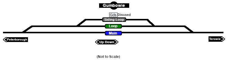
Facilities:

Loop
 |
|
|
|
|
|
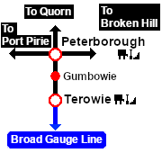
Distance from Terowie: 21¾ kms, 13½ miles from Peterborough: 11¼ kms, 7 miles
Unmanned location on the Peterborough-Terowie Line .
Crossing and siding loops.
A signal box and a small station building that were originally present on the main line had been removed by the start of the 1960s. After Belalie North was bypassed by the gauge conversion (1969-70) Gumbowie at 610m (2001ft) became the highest point in the SAR system.
The main line and crossing loop were converted to dual gauge with the addition of a broad gauge (5ft3in - 1600mm) track to the existing narrow gauge (3ft6in - 1067mm) main line and loop in 1970 but the siding remained narrow gauge only. The Peterborough-Terowie Line was closed in 1988.
Today nothing remains at Gumbowie to indicate that it was once a railway location.
|
|
|

 |
