SAR Yangya V2
From TrainzOnline
(Difference between revisions)
(Created page with "<!-- V2.0 (seperate V1.0 file) --> <table> <!-- BEGIN TOP TABLE --> <tr valign="top"> <td width=750> <table width=750> <!-- BEGIN TABBED link list with Home page active--> ...") |
|||
| Line 30: | Line 30: | ||
<table width=750> | <table width=750> | ||
<tr valign="top"> | <tr valign="top"> | ||
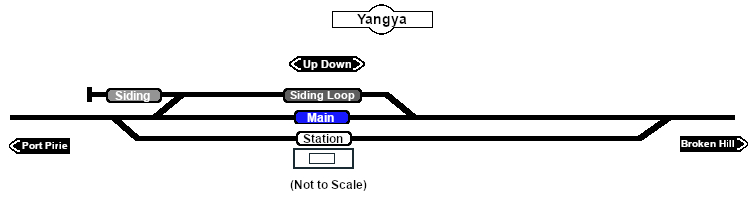
| − | <td>[[image: | + | <td>[[image:SAR_Yangya.png|link=|alt=Yangya map]]</td> |
</tr> | </tr> | ||
<tr valign="top"> | <tr valign="top"> | ||
Revision as of 20:28, 25 April 2024
|
 |