From TrainzOnline
(Difference between revisions)
|
|
| Line 33: |
Line 33: |
| | </tr> | | </tr> |
| | <tr valign="top"> | | <tr valign="top"> |
| − | <td align="center"><span style="font-weight: 700;">This is the original <span style="color: blue;">v1.0 Caltowie Map and description</span>. For the latest <span style="color: blue;">SAR Peterborough Narrow Gauge Division v2.0</span> version click <span style="background-color: yellow;">[[SAR_Caltowie_V2|here]]</span></span>. The '''v2.0''' version of the route and sessions requires '''Trainz Plus''' or '''TRS22'''<br> | + | <td align="center"><span style="font-weight: 700;">For <span style="color: blue;">SAR Peterborough Narrow Gauge Division v1.0</span>. For the latest <span style="color: blue;">V2.0</span> click <span style="background-color: yellow;">[[SAR_Caltowie_V2|here]]</span></span><br> |
| | [[Image:line740.png|link=]]</td> | | [[Image:line740.png|link=]]</td> |
| | </tr> | | </tr> |
Latest revision as of 10:29, 30 April 2024
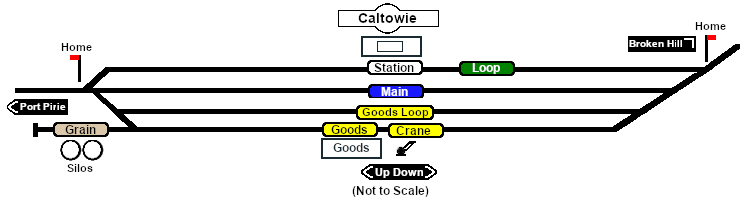 |
For SAR Peterborough Narrow Gauge Division v1.0. For the latest V2.0 click here
 |
| Commodities:
|
|
Facilities:

Loop
 |
|
|
|
|
|
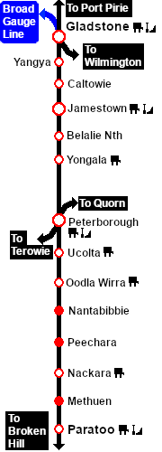
Distance from Gladstone: 18 kms, 11½ miles from Peterborough: 47½ kms, 29½ miles
Manned station on the Port Pirie-Broken Hill Line .
Station loop, goods and grain loop, a goods loop, and a grain storage siding.
After the conversion of the line to standard gauge (4ft8½in - 1434mm) in 1969-70 Caltowie became just a crossing loop and a grain terminal. There are no passenger services.
|
|
|

 |
